Mixed Used Development, New Delhi
Academic Work: New Delhi, India
Faculty: Sunit Mohindru,

Responsive Design Components
I would like to provide a system for a sustainable transit system along with a mixed-use built edge to reach the riverfront. Having people feel safe and belonging is an idea here to generate the notion of care. To do so, I need to analyze the transportation and commercial systems of the study site. Connections in this study area, as well as the larger urban context, are needed. Some parameters would be :
No. of transit
No. Of stops
No of people being catered
No of the entry points to the riverfront
The business number at the riverfront,
The residential number at the river edge
Unwanted/ pedestrian-unfriendly faces to the edge
Thumb rules of no. of stops needed, no. Of entries needed, etc.
Spatial Query analysis

Describe your image

Describe your image
Describe your image
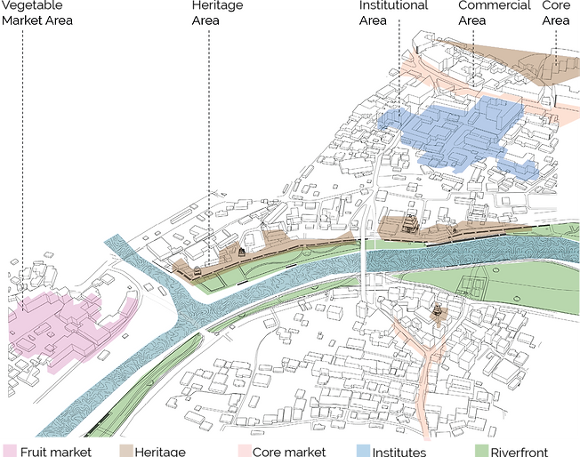
The spatial query, as well as the cluster map of the study area, shows the buildings surrounding the important junctions. These are unsurprisingly areas where most commerce is happening. This is the area in which we would want to be coherent with the riverfront edges rather than separated.
Network analysis
Walkshed

Here, we see the immediate 5 mins walkshed area and pathway from each of these areas.

Shortest distance


Describe your image

Describe your image
All the shortest distance for these three neighborhoods pass through the riverfront

Central Place - Multi-Point Accessibility
Isovist Simulation
Isovist Simulation

Describe your image

Describe your image
Surprisingly, the main walkable shed area is the waterfront area in which the area currently the backside of the city.
The walkshed of the three neighborhood area can be seen in the adjacent diagram. The red area is the most walkable pathway for all three destinations. Here the three destinations.

The 2D multi-point Isovist shows the line of sight and the sight range in the major transit routes of the site area. The first map (1) shows the visibility range in the existing route if major transit, while map (2) shows possible future transit routes and the visibility ranges.
The site boundary includes the riverfront of Kathmandu with three different neighborhoods. The transition from area 1 to 3 is visible in this isovist stimulation.
Design Component Explanation & Scheme


Ownership of a place comes with the functionality of the space. The basic need to be able to use this riverfront park is to be able to access it. The entry points to the Bagmati riverfront seem to be lacking accessibility. Some transit routes exist but the location and conditions of the transit stops are unclear and bad respectively.
How many people the entry points cater to? What all commercial facilities are being provided to them at what proximity. Can I ride to these locations? Are there sheltered bus stops? bike stands? water? There are a number of existing typologies that need to be introduced to the site for the entry points to functions properly.
The goal of this project is to find locations where improvement of the quality of access points can be pinpointed. The components that can be introduced are :
a. Bus stop
b. Bike stands
c. Bioswales
d. Garbage bins
The exterior performance matrix would be:
1) Transit routes that exist to cater to the points. Are they enough?
2) How much population density is it catering to?
3)Proximity to the next access points and bus stops.
Bus stop - each 1/4 miles
Bin distance - 1/8 miles
Bike stands - with each stop
4)Space available for the components.
Large Bus stops- 15’ X 7’
Small Bus stop- 5’X5’
Cycle Stand - 6’ X distance

component A - Big Bus stop 15’ X 7’

component C - Bike Stand 6’ X 8’
component B - Small Bus stop 5’ X 5’

Internal performance matrix
1)Are the components covered? (Since Kathmandu is a very rainy as well as sunny area.)
2) Is it powered with solar/ electricity?
3) are there electric charge plug points?
4) Garbage bins
5) Are there seatings?
6) Is the architecture style to context?
component D - Garbage Bins
Site Area
component D - Garbage Bins

Scenario1- Existing transit stop

Here in this exercise, two scenarios in which the transit stops can be implemented are listed. Here we are trying to figure out if there are possible profits or changes in the given two conditions.
Scenario 1 - components installed in the current stops ( which are also unbuilt but support transit systems)
Scenario 2- Additional stops along the new riverfront are added at appropriate intervals.
The site boundary includes the riverfront of Kathmandu with three different neighborhoods.

Scenario2- New transit stop

Walkshed
Scenario1- Existing transit stop networks analysis
Scenario1- Existing transit stop networks analysis

Scenario2- New transit stop network analysis

Not only have the transit area increased in scenario 2 when the required stops were added but we almost get full walkshed coverage in this area. Thus, making this area very accessible by public transport and making it easy to reach entry points to the riverfront.

Scenario1- Existing transit stop simulation
The simulation shows the influence of the existing transit route. Here there are several areas where the stops are not being able to impact. As the pie chart below shows, the percent of land touching the transit is about 1/4th of the total study area.
Scenario2- New transit stop simulation
Here we have added more transit points according to the external parameter to distance a bus stop, i.e 1/4 miles. Unsurprisingly, their transit area is almost double than of scenario1.


